English / Japanese

Chawmos Festival – Shishao Adu: The Kalash Rituals Still Alive to This Day

The ceremony to welcome the god Balimain of Kalash had finally begun. The following is a report on the women’s purification day known as “Shishao Adu.”

The day before Shishao Adu is a day for preparing the stone slab with which the Shishao, the bread for the women’s purification ceremony, will be made. The men go into the mountains to look for suitable stone slabs and leave them in a safe place, so that the women don’t touch them until they are ready to use. Meanwhile, the women prepare the flour used to make Shishao.

A man carrying the stone slab to be used in the making of Shishao.

On the morning of Shishao Adu, women gather on the riverbank to prepare for the purification. They bathe in the hut and wash their hair. After this, they cannot bathe until the sacred period is over.

Girls making themselves ready.

Shishao Adu is a day of purification for women. After this day, no newcomers are allowed to enter the Rumbur Valley. No exception is made for foreigners, nor for Muslims living in the valley—they are likewise not allowed to enter the village of Kalash. The female Kalash relatives who come from Bumburet to celebrate the children’s rite of passage known as “Goshnik” must also undergo this purification. We foreigners were also purified. When I walked around the village, people asked me if I had showered, and if I was wearing new clothes. They believe that if anyone who does not follow the regulations of the Kalash religion is in the valley, it will bring them misfortune.

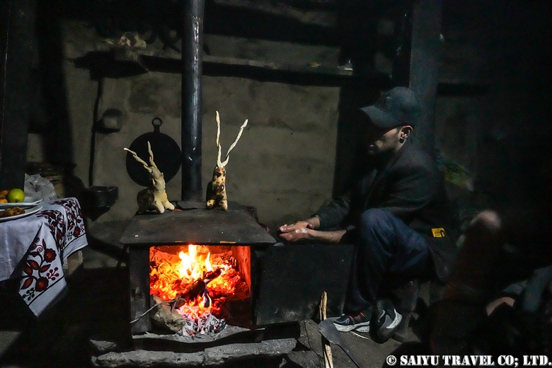
Shishao making begins at the Temple.

A man kneads purified dough to be used for the making of Shishao. The men’s hands are purified, and they are not allowed to touch anything other than the ingredients for Shishao—including themselves.

Using stone slabs and stones from the mountains, the men crush the walnuts which will act as filling for the bread.

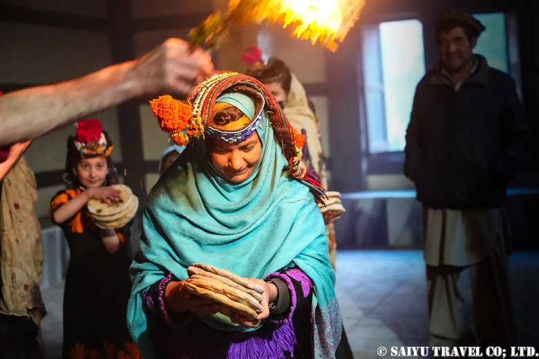
Men are required to bake five Shishao for each female member of the family, and in families with many female members, baking Shishao can start even in the early morning.

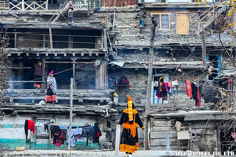
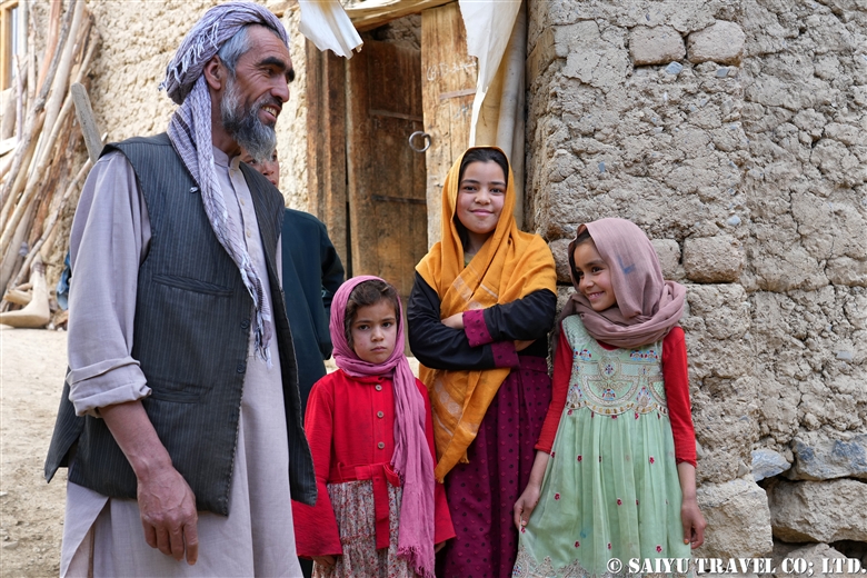
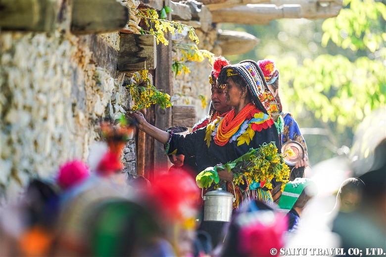
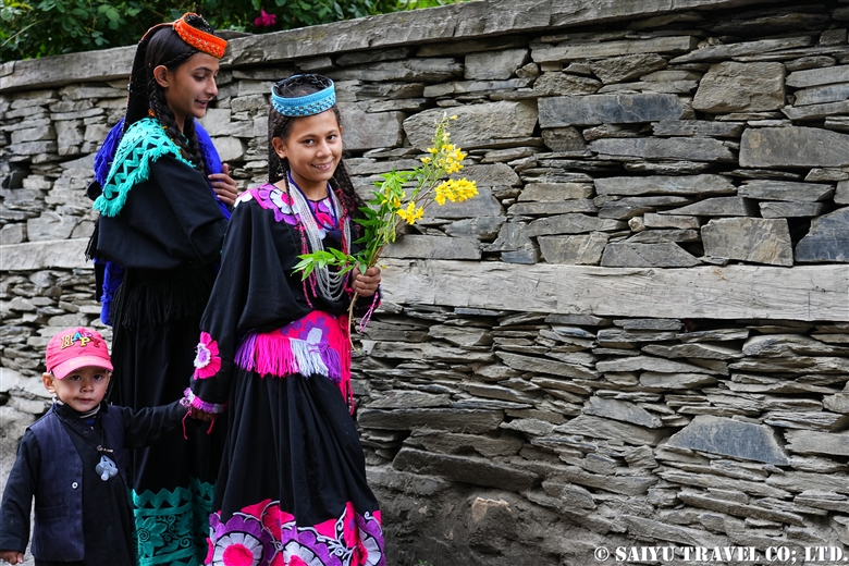
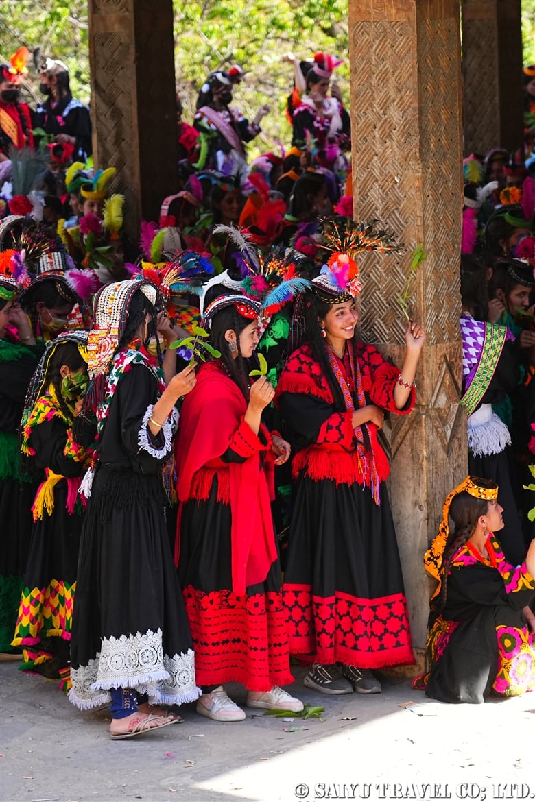
The women’s purification ritual, Shishao Suchek, had begun. The women prepared new clothes, and some of the girls were dressed up almost as much as they are during the spring Joshi festival.

First, one must purify their hands with water.
Five pieces of “Shishao” (walnut bread) are handed out.
The women are purified with smoke from a flaming juniper branch.

A woman with a very innovative headdress. She said her mother made it for her.

A traditional-style headdress known as a Kupas. Its colors are very modern. The traditional materials and colors that are typically shown in books are nowhere to be seen these days. It seems that Kalash women are always chasing the latest fashions.

The Shishao Suchek ritual at Temple Jestak Han had finally begun. Notably, it can also take place outside, in the open air.

Female members of the family gathering at the temple.
A girl receiving purification.
The female purification ritual, Shishao Suchek.

After this purification, the woman must remain pure for seven days. This involves a serious of strict rules, such as not touching Muslims, not eating chicken, eggs, cow’s milk & dairy products, honey, and so on.

Getting the opportunity to see these people live their lives and practice their faith was truly a beautiful sight.


Text & Photo: Mariko SAWADA

Visit: Dec 2024, Kalash Valley – Khyber Pakhtunkhwa

*The information presented here is based on interviews with people in the area. Please note that the descriptions and explanations of the rituals may differ depending on the source.

Chawmos Festival – Kutram: The Kalash Rituals Still Alive to This Day

The Joshi Spring Festival: A Kalash Ritual

*Contact us, Indus Caravan for more information or to make arrangements for visiting Kalash valley.

*Please follow us on YoutubeInstagram & Facebook

Category : - Kalash Valley > ◆Khyber Pakhtunkhwa
Tag : , , , , , , , , , , , , , , , , , , , , , , , , , , ,

Chawmos Festival – Kutram: The Kalash Rituals Still Alive to This Day

It is early December in the Kalash Valley. The harvests have all been completed and the livestock have come down from the mountains. The ceremony to welcome the God Balimain of Kalash has begun. It includes rites of passage, purification, and sacrifice—all culminating in a farewell to Balimain, complete with torches and a large bonfire. The following is a report on a trip that brought me into contact with the rituals of a deep faith that continues to thrive in the modern age.

During the sacred period of Chawmos, Muslims are not allowed to enter the valley. Since neither staff nor drivers from Islamabad could enter the valley, Kalash staff came to Ayun to pick me up.

In the village of Kalash, a lot of laundry was hung out to dry to ensure people can wear new clothes during the sacred period. Before the purification ritual, one must take a bath and put on new clothes.

Sharabira displayed in a house

I made it just in time to be able to observe the Sharabirayak ritual in the Bumburet Valley. The word “Shara” means markhor and the word “Bira” means male goat. After the women bake walnut bread with cheese to be distributed the next day, the men knead dough, which they shape in the form of either markhor or male goats. These statues are then baked in a fireplace. This ritual is called Kutram.

Sharabira making takes place at night. When I visited, there was no electricity in the valley, and I was able to glimpse the beautiful sight of a woman baking walnut bread by the light of a stove fire.

Afterward, the purified man kneads purified dough and begins to sculpt animal shapes.

He proceeded to bake them on the stove.

The completed sharabira on display

The ritual of Kutram is performed in each household as well as in the temple of the goddess Jestak. The wheat collected from each family is used to make a Shara (markhor) at the Jestak Han temple. At night, the men gather to make Sharabira and spend the night painting on the walls and drinking until early in the morning. At around 4:00 a.m., they make a “tchich tchich” sound—intended to resemble the call made when chasing goats—urging the Sharabira to go to a place called “Dezelawat.” The people of Kalash believe that the souls of the Sharabira go to Dezelawat, which is located near the Afghan border.

A drawing of Sharabira on the wall of the Jestak Han temple. Three Shara (markhor) are placed by the altar.

The drawings on the walls of the temple are painted with charcoal made from burning walnut bark prepared by the women.

A painting from Kutram in 2024

For those unfamiliar with the markhor, it is the national animal of Pakistan and is known to be extremely valuable for trophy hunting. In the 2024-25 winter hunting season, permission to hunt three Kashmir markhor was given, and each was auctioned off for between $231,000 and $271,000. It is said that 80% of the income from trophy hunting is returned to the local community, and in order to increase the number of trophies, conservation is carried out. Though this initiative has led to the number of markhor increasing, as someone who loves animals, I feel rather conflicted about this.

Kashimir markhor (Toshi Shasha game reserve)

The markhor is a highly sacred animal to the people of Kalash. They can be seen in Chitral Gol National Park and nearby game reserves. Males with large horns are usually found at higher elevations in the mountains, but during the winter breeding season they come down to lower elevations, making it possible to observe them. The variant in this region is a subspecies, and is known as the Kashmir markhor.


Text & Photo: Mariko SAWADA

Visit: Dec 2024, Kalash Valley, Toshi Shasha – Khyber Pakhtunkhwa

*The information presented here is based on interviews with people in the area. Please note that the descriptions and explanations of the rituals may differ depending on the source.

The Joshi Spring Festival: A Kalash Ritual

*Contact us, Indus Caravan for more information or to make arrangements for visiting Kalash valley.

*Please follow us on YoutubeInstagram & Facebook

Category : - Kalash Valley > ◆Khyber Pakhtunkhwa
Tag : , , , , , , , , , , , , , , , , , , , , , , , ,

Deosai National Park Wildlife Camp in Autumn – In Search of the Himalayan Brown Bear

In autumn, we went to Deosai National Park in search of Himalayan brown bears before they hibernate. This is a report on the wildlife of the plateau as autumn deepens.

We entered Deosai National Park from the Chilum Check Post on the Astor side. At the entrance, there was a very beautiful photo of a Himalayan brown bear in summer.

At Chilum Check post at the entrance to the national park

From the entrance to the National Park in Chilam, we gained more and more altitude as we headed toward the plateau. On the way, we observed birds. We were able to spot only a few birds on the plateau this time—we found many more on the way up from Chilam to Sheosar Lake.

A juvenile fore-fronted serin. Often seen on the road from the Astor Valley to the Deosai Plateau
A Siberian stonechat, a passage migrant
A robin accentor. It can be seen from the Astor Valley to Deosai, where it migrates to an altitude of around 2,000m in winter.

As we approached Sheosar Lake with Nanga Parbat in sight, we saw an animal that looked like a dog ahead of us. “Do dogs come here?” I asked to the staff.  “No, I don’t think so—it’s too far from the houses,” he replied. We searched for a while but could not find the animal. Thinking we had simply misidentified it, we went to the shore of Sheosar Lake instead. There, we happened to come across the animal in question—it had been a wolf. In the Deosai Plateau, Tibetan wolves are more difficult to run into than even brown bears!

A Tibetan wolf: A medium-sized wolf and subspecies of the grey wolf. It is found in Tibet and the Himalayan region.
Tibetan wolf

This wolf did not appear to be a pack member, but rather a lone wolf. We had two subsequent opportunities to observe Tibetan wolves at a distance during our stay on the Deosai Plateau, but both times they were alone. The national park staff also found it unusual to see wolves three times during our five-day stay, and speculated that the wolves might have been actively hunting for marmots before the rodents entered hibernation.

Once on the Deosai Plateau, we passed through Sheosar Lake and Kala Pani to the campsite at Bara Pani.

Nanga Parbat (8,126m), the world’s 9th highest peak, seen from Sheosar Lake (4,200m)
long-tailed marmot

There are many tourists in the vicinity of Sheosar Lake, and the long-tailed marmots show up expecting to be fed. Some of them are quite accustomed to people—no doubt the national park authority should be stricter about tourists feeding the wild animals.

Our camp in Bara Pani. This is a private camp established in the ranger staff facility area. The Indus Caravan camping team, active in the mountains during the summer, has set up a tent, a dining tent, and a toilet tent. We camped out in the wilderness, with a river flowing right in front of our tents.

A winter migratory Pallas gull that was always in the river in front of our tents
Every morning, a pair of common mergansers could be seen in the river. These are also winter migratory birds.
Walking on the Deosai Plateau. The snow-capped mountain in the distance is Nanga Parbat (8,126m).

We spotted a male Himalayan brown bear. We photographed him from a distance so he wouldn’t notice us. The wind direction was not in our favor, so we were only able to observe it from a distance. We then tried to get closer to the mother and cubs who were behind this bear.

Himlayan brown bear

We spotted a male Himalayan brown bear. We photographed him from a distance so he wouldn’t notice us. The wind direction was not in our favor, so we were only able to observe it from a distance. We then tried to get closer to the mother and cubs who were behind this bear.

What an adorable sight: a Himalayan brown bear and her cub
Walking on the plateau is difficult. The uneven terrain and wetlands in this area make traversal tricky—one has to be very careful.
Himalayan brown bear

The Himalayan brown bear is a subspecies of brown bear that inhabits the northern mountainous regions of India, Pakistan, and Afghanistan. In the last census (2022), the presence of 77 of these animals was confirmed in the national park. Three animals were fitted with transmitters in the autumn of 2023, and their previously unknown hibernation sites were at last discovered. Two of the three had descended into the Astor Valley to hibernate, and one was hibernating near Bara Pani on the Deosai Plateau.

Himalayan brown bear

The wind was on our side, and the brown bears began to come closer to us. They seemed to know that something was out there and watched us with interest.

An adorable-looking Himalayan brown bear
Picnic lunch on a plateau

We had lunch on the plateau with our observation team. When I served onigiri (rice balls), one of the staff members said, “This is Japan’s anime food!” It turned out that our animal-loving staff also loved Japanese anime.

As an additional note, Himalayan brown bears can be very timid and can only be observed from a distance. The small black dot in the center of the photo below is a Himalayan brown bear. At night, however, they become bolder—and even approached our camp.

The small dot in the center is a Himalayan brown bear
A Himalayan brown bear came to the campsite at night.

A Himalayan brown bear appeared at our camp. When no one is around, they approach camps looking for food. This one didn’t run away immediately when we shone a light on it. Though they are rather timid during the day, at night they are very imposing…. I wonder if they think we can’t see them in the dark… Himalayan brown bears came on all four nights we spent there. Moreover, it was a different bear each day. There is an urgent need to control food and garbage at national park campsites to prevent accidents.


Text & Photo: Mariko SAWADA

Visit: Sep 2024, Deosai National Park-Gilgit Baltistan

Visit our web site “Wildlife of Pakistan

*Contact us, Indus Caravan for more information or to make arrangements for your  ” Wildlife observation ” in Pakistan.

*Please follow us on YoutubeInstagram & Facebook

Category : ◆ Gilgit-Baltistan > - Deosai National Park
Tag : , , , , , , , , , , , , , ,

Over the Baltoro Glacier, the Trek to Broad Peak B.C. and K2 B.C., Part 2

The following is the continuation of a photo report of Teppei Kamitani’s 2024 season excursion to the Baltoro Glacier—titled “Over the Baltoro Glacier to Broad Peak B.C. and K2 B.C.” Many spectacular drone aerial photographs are included within.

The second part of the blog traces and documents (with photos) the trek to Concordia in the following order: [Urdukas → Goro Ⅱ → Concordia → Broad Peak B.C. → K2 B.C.→ Concordia].

Over the Baltoro Glacier, the Trek to Broad Peak B.C. and K2 B.C., Part 1

Day 7: Urdukas to Goro Ⅱ

We left Urdukas at 7:00 a.m. and were up on the Baltoro Glacier within 30 minutes. Today’s route was a continuous up-and-down walk along the moraine of the Baltoro Glacier.
It was a clear day, so even though we were on a glacier, the sunlight made us feel warmer than the real temperature let on. We proceeded deeper into the moraine, wearing light clothing.

The mountain rising high in the front is Gasherbrum IV Peak (7925m)
Gasherbrum Mountains seen behind the glacial lake
Masherbrum (7821m), the 22nd highest peak in the world, designated as K1 according to surveying notation

At 11:45 we arrived at our lunch stop, Goro I (4,100m), where we had ourselves a lavish lunch at a table in the middle of the glacier. On the outward trek, we did not stay here but continued instead on to Goro II.

Arrival at Goro I (4100m). We enjoyed lunch at a table in the middle of a glacier with a luxurious view.
Baltoro Glacier is approximately 100 meters thick, equivalent to 25 floors of a building!

After another 2.5 hours, we arrived at Goro II (4,380m), also a camp on the glacier, at 15:00. After Goro II, we slept on the ice, as the temperature continued to drop in both the morning and evening. It was cloudy on the outward trek, but on the way back to Goro I, we had an excellent view of the Gasherbrum mountains. The -6℃ temperature in the morning, however, was less than excellent. My hands were freezing cold.

At Goro II Camp, treated to a good view of Masherbrum. A glimpse into the tour kitchen and dining room
The Milky Way over Masherbrum
Thisphoto was taken on the way back

Day 8 & 9: GoroⅡ to Concordia

Waking up in the morning at the camp on the glacier, the cold air—which now felt stronger than before—imbued us with a sense of determination. Under slightly overcast skies, we departed for our destination, Concordia. Continuing from the previous day, it was just up and down on the glacier moraine. Thankfully, however, the path was quite gentle and flat in many parts, making for an easy walk.

With the morning sun shining through the clouds, we walked through the icy world to reach Concordia

In the afternoon, cold rain began to fall, which was hard on our tired bodies at the end of the day. We continued further into the depths of the mountain to a campsite where we could see K2 in front of us. Finally, we arrived at the Concordia camp, the turnaround point.
Unfortunately, K2 was still obscured by clouds when we arrived and did not grace us with its presence, but we still held on to hope. We stayed at the Concordia Camp for two days, which served also as time to rest.

When we arrived at Concordia, the snow cover had turned the surroundings into a world of silvery white!
A spectacular serac zone

Day 10 Concordia to Broad Peak B.C.

In the morning, we woke up to steady snowfall. Visibility was almost zero, making it difficult for the porters and horses to move forward, so we had to temporarily postpone our departure and wait until 9:00 a.m. The sun came out before 9:00 a.m., and a blue sky quickly revealed itself before us. It was time to set out!

Early in the morning it was snowing, with zero visibility, but it cleared up around 9:00 a.m.
Now it was time to depart for Broad Peak B.C.!
The ordinary moraine was covered with snow, making it look almost fantastical

We changed to chain spikes/light crampons after 10 minutes of walking and passed through a serac zone. The route seemed to have changed a bit, and the serac was very gentle—traversable even without spikes. After the ups and downs of the large moraine, we simply walked along the side moraine of the Godwin-Austen Glacier, arriving at Broad Peak B.C. at about 14:00.

Broad Peak B.C. in the middle of Godwin-Austen Glacier
Broad Peak seen from the BC is divided into three peaks. From the back left: Broad Peak North Peak, Broad Peak Central Peak, and Broad Peak Main Peak (8,051m)
K2 (8,611m) at sunrise is a breathtaking sight

Day 11 Broad Peak B.C. to K2B.C and Back

Finally, we set out for K2 B.C. This was a day round trip from Broad Peak B.C. We started at 7:00 a.m. and had a very pleasant 2 ½ hour flat walk up an icy area next to a moraine. Then we trekked up and down the messy moraine to our first destination, K2 Memorial. The K2 Memorial is built on a very steep rock slope, so it was tough to climb up, but we visited and said a prayer for the climbers who lost their lives in the mountains of the Baltoro Glacier, including K2. After descending to the bottom of the rock tower, we had a quick lunch of onigiri (rice balls) and then continued further along the gentle moraine, eventually arriving at K2 Base Camp at 11:30!

To K2 B.C.
Memorial to the many climbers who lost their lives in the mountains of the Baltoro Glacier
We reached K2 B.C. (5,150m). Our guide found the fallen K2 BASE CAMP sign in the moraine and took a commemorative photo

Day 12: Broad Peak B.C to Concordia

At Broad Peak B.C., where we stayed for two nights, K2 came into view around 5:35 a.m., glowing in the morning sun, giving the members a chance to gaze at the world’s second highest peak. After breakfast, we headed back to Concordia.

K2 shining in the morning glow seen from Broad Peak B.C.
A view of the base camp. Members gazed at the world’s second highest peak

As on the outward trek, we walked for 3 hours on gentle moraines, passing army camps. After 1 hour of walking along the moraine & serac belt, we arrived at Concordia. At Concordia, the staff had set up camp in the exact same spot as our previous stay and had prepared a welcome drink and lunch for us. I have nothing but gratitude for them and their consistently prompt work.

Passing through the serac belt again, we return to Concordia
Our camp visible at the foot of Mitre Peak, behind the serac belt
At night, the moonlight illuminated the mountains, creating a beautiful scene

We then said goodbye to K2 from Concordia and retraced our outward route for another 5 days, ending our long trek in Askole. The entire trip took 17 days. At the finish line, the staff congratulated us and toasted us with drinks, in the form of Coke. Some of our members commented that they had never enjoyed a Coke so much in their lives. It must have been because of the overwhelming accomplishment they felt after walking all the way back. Thank you very much, everyone!

Today was the day we said goodbye to K2. We were about to go back the way we came


Photo & text : Teppei Kamitani

Visit : Aug-Sep 2024 Baltoro Galcier- K2BC


▼Related Articles

Youtube : CONCORDIA 360 DEGREE

Youtube : Our baltoro Trek in 1 Min !

K2 & Baltoro Glacier Trekking 2022 (Part 1) Skardu to Paiju

K2 & Baltoro Glacier Trekking 2022 (Part 2) Paiju to Khoburtse

K2 & Baltoro Glacier Trekking 2022 (Part 3) Khoburtse to Urdukas

K2 & Baltoro Trekking 2022 (Part 4) Urdukas to GoreⅡ

K2 & Baltoro Trekking 2022 (Part 5) GoreⅡ to Concordia

Staying in Concordia, surrounded by the high Peaks of the Karakorum: K2, Broad Peak, Gasherbrum Mountain Range

*Contact us, Indus Caravan for more information or to make arrangements for your Baltoro Glacier K2BC trek.

*Please follow us on YoutubeInstagram & Facebook

Category : - Baltoro Glacier & Concordia > - Baltoro Glacier & Concordia > ◆ Gilgit-Baltistan > ◇ Mountain of Pakistan
Tag : , , , , , , , , , , , , ,

Over the Baltoro Glacier, the Trek to Broad Peak B.C. and K2 B.C., Part 1

The following is a photo report on a 2024 season excursion to the Baltoro Glacier—titled “Over the Baltoro Glacier to Broad Peak B.C. and K2 B.C.“—carried out by Teppei Kamitani, a guide from Japan who has visited and photographed the glacier many times.

The first part of the blog traces and documents (with photos) the first half of the trek in the following order: [Askole → Jhora → Skam Tsok → Paiju → Khoburtse → Urdukas].

My first step was to take a domestic flight from Islamabad to the town of Skardu, the gateway for trekkers in the area. Weather permitting, it’s possible to get a spectacular view of many mountains—including Nanga Parbat—during the flight, but this time it was cloudy and we could not see it. However, had the flight been cancelled, it would have taken two days to travel there on land, so we considered ourselves lucky that we were able to arrive safely.

Town of Skardu, the gateway to trekkers

The day after arrival at Skardu was also a backup day in case of flight cancellations, as well as for obtaining permits and other bureaucratic formalities. During this time, it was possible to head out to the Deosai Plateau to acclimatize oneself to the altitude of 4,200 m.

The following day, we headed to Askole, the starting point of the trek. The route took us through the Shigar Valley, passing the Sarfaranga Cold Desert and viewpoints overlooking the valley. The road became steeper and steeper as we approached Ascole, with more ups and downs along the riverside slopes.

Heading towards Askole by 4WD

Day 1: Askole-Korophong-Jhola

At long last, the trek began from the lush green village of Askole. On the way, we completed the various formalities at the office in Testay Village, the last inhabited settlement in this vicinity. Beyond this point, a vast, uninhabited path stretched out before us.

Starts in the lush green village of Askole
Walking through desolate land

About four and a half hours after leaving Askole, we had lunch at Korophong, a camp in the end moraine of the Biafo Glacier, which flows from the Latok Mountains. We continued walking along the Braldu River and Jhola Camp came into view on the other side of the Domordo River. Here we crossed the recently opened Snow Leopard Bridge to reach the new Jola Camp.

Lunch at Korophong inside the Biafo Glacier
New Jhora Camp, located along the riverbank

Day 2: Jhola to Skam Tsok

The trail follows the Braldu River with gentle ups and downs, the second half of the day walking along the cliffs. When Skam Tsok comes into view in the distance, we saw Broad Peak (8,051m), the 12th highest peak in the world.

Broad Peak(8,051m) can be seen in the distance

We arrived in Skam Tsok at 11:20, taking about four and a half hours. After lunch, we relaxed with a tea break to keep our spirits up.

Skam Tsok camp and the big rainbow in the sky

Day 3: Skam Tsok to Paiju

This was the day of the half-day walk to Paiju, the camp in front of the glacier. Two and a half hours after we’d passed the gentle ups and downs from Skam Tsok, the Baltoro Glacier began to come into view. The iconic mountains of the Baltoro Glacier, such as Trango Castle and Cathedral, were also visible.

We continued up and down the river bank path
We crossed the log bridge carefully
The Baltoro Glacier finally came into view

The second half of the route followed a traverse path to reach Paiju Camp (3,450m), which was covered with poplar trees. The clean mountain water jabbered around us, and even gave us the opportunity to wash our clothes. We put chairs in front of our tent and had ourselves a relaxing afternoon. We were refreshed for the trek up the Baltoro Glacier…

Before Paiju, the trail enters the cliff path again, with more ups and downs
The campsite at Paiju was delightfully well-shaded. Once up on the glacier, there would be no shade at all

Day 4: Paiju to Khoburtse

At long last, this was the day we’d walk to the Baltoro Glacier—though it would end up being a long one. We walked to the Baltoro Glacier and reached the glacier tongue in ninety minutes.

Finally, the edge of the Baltoro Glacier tongue

There was a bit of sunshine at first, but clouds started to gather from the lower part of the Pailu and it began to rain. We followed the glacier’s outlet, gradually making our way up the mountainside, and had lunch at Liligo. From here, wearing helmets, we crossed a slope where there was a risk of landslides. What awaited us at the end, on the opposite bank of the glacier river, was the camp of Khoburtse (3,940m)!

Thanks to this small wooden bridge, we didn’t have to wade across the river. We crossed the bridge on our way to the Khoburtse campsite
The North Star, Trango Castle, Biale, and the Cathedral …. night photography at Khoburtse Camp site

Days 5 & 6: Khoburtse to Urdukas

We spent four hours trekking to Urdukas (4,050m). The plan for today was not to enter the Baltoro Glacier, but to cross two unnamed glaciers on its tributaries. As we made our way up the gently sloping upper reaches of the glacier, there was a point where we could see Broad Peak, Gasherbrum II, III and IV, but this time they were obscured by clouds.

Morning in Khoburtse. The rocky peak in the foreground is Trango Castle (5753m)
We didn’t enter the Bartolo Glacier, but traversed the side slopes. There was a lot of up and down

Urdukas means “broken boulder,” so it was fitting that there were actually boulders scattered around the campsite. The Baltoro Glacier lay directly in front, and beyond that, the Trango mountain range, the Cathedral, the Biale Glacier flowing down from Biale, and other famous peaks and glaciers could be seen in a panoramic view.

Urdukas camp site where we stay for two nights, is a high vantage point overlooking the Baltoro Glacier.
The Baltoro Glacier and rock peaks as seen from the rock terrace of Urdus camp
The Baltoro Glacier and the famous mountain range in the direction we are heading to

This trip would not have been possible without the support of the local staff.
We stayed at the Urdukas camp, which had running water, for two nights, including a rest day. I think this break probably really helped our guides refresh mentally as well. The local staff who supported the trip also took a break and sang along, following Ali’s lead.

Ali led the porters in singing


To be continued in the second half…


Photo & text : Teppei Kamitani

Visit : Aug-Sep 2024 Baltoro Galcier- K2B.C.


▼Related Articles

Youtube : CONCORDIA 360 DEGREE

Youtube : Our baltoro Trek in 1 Min !

K2 & Baltoro Glacier Trekking 2022 (Part 1) Skardu to Paiju

K2 & Baltoro Glacier Trekking 2022 (Part 2) Paiju to Khoburtse

K2 & Baltoro Glacier Trekking 2022 (Part 3) Khoburtse to Urdukas

K2 & Baltoro Trekking 2022 (Part 4) Urdukas to GoreⅡ

K2 & Baltoro Trekking 2022 (Part 5) GoreⅡ to Concordia

Staying in Concordia, surrounded by the high Peaks of the Karakorum: K2, Broad Peak, Gasherbrum Mountain Range

*Contact us, Indus Caravan for more information or to make arrangements for your Baltoro Glacier K2BC trek.

*Please follow us on YoutubeInstagram & Facebook

Category : - Baltoro Glacier & Concordia > - Baltoro Glacier & Concordia > ◆ Gilgit-Baltistan > ◇ Mountain of Pakistan
Tag : , , , , , , , , , , , , , , , , ,

Kaghan Valley ; Himalayan Bird Watching in Summer

The best places to go birding and see Himalayan birds in Pakistan are the Margalla Hills in winter and the Kaghan Valley in summer. Birds that have spent the winter in the Margalla Hills, the Punjab Plains, and even in places as far away as southern India and Sri Lanka, come to the Kaghan Valley around May to breed and spend the summer. They reside in the valley’s moist temperate Himalayan forests (comprised mostly of evergreen conifers with some deciduous trees), which span an area of around 2,000~2,800 m.

The following is a record of my birding experience in the Kaghan Valley in late May. Many places in the Kaghan Valley, including Narang, have undergone development to accommodate domestic tourists (if I am to be honest, overtourism has left them in a terrible state), and birdwatchers are advised to avoid visiting during peak season or on weekends.

We walked along the slopes of a coniferous forest with giant pine trees and explored the streams and cultivated areas. During this visit, in addition to birds, we were able to observe two species of flying squirrels (the Kashmir flying squirrel and the red giant flying squirrel), as well as a rare species of Kashmir langur.

Here are some of the birds we encountered during our three days and two nights of birding.

Great Barbet

This is a species I have encountered many times. The great barbet is widely distributed in Southeast Asia and South Asia, but is found only in limited areas in Pakistan, such as the Kaghan Valley and Murree. Being of 32~35 cm in length, it is the largest bird in the barbet family.

Verditer Flycatcher

A verditer flycatcher (male). This summer bird is easy to observe as it often perches on top of tall trees.

Yellow-billed Blue Magpie

Yellow-billed blue magpie are omnivores and can be encountered in a variety of situations. This family of corvids can be seen year-round in the Himalayan foothills.

Himalayan Bulbul

A Himalayan bulbul. This is a species of bulbul found year-round in the area from Swat Valley to Chitral, and from Margalla Hills to Kaghan Valley.

Streaked Laughingthrush

A streaked laughingthrush. This bird is found year-round in northern Pakistan and could be observed daily in the Kaghan Valley.

Grey Bushchat

A grey bushchat (male). This species makes short migrations (between 1900 m~3000 m) in the Himalayas and can be seen everywhere in the Kaghan Valley in summer. Females are buff (cream to light brown) in color.

Russet Sparrow

A russet sparrow (male). This species seems to be seen year-round in the Kaghan Valley, but also migrates to the Punjab region in winter.

Blue-capped Rock Thrush

A blue-capped rock thrush (breeding male). A summer bird in northern Pakistan. They migrate to southern India in winter. It would be great to get a picture of the breeding males!

Lemon-rumped Warbler

A lemon-rumped warbler. This bird makes short winter and summer migrations in the Himalayan foothills.

Green-backed Tit

A green-backed tit breeding in a hole in a large dead pine tree. They can be seen year-round, but some migrate down to the Margalla Hills in winter.

Western Crowned Warbler

A western crowned warbler, a summer bird of northern Pakistan that migrates to peninsular India for the winter.

Rufous-bellied Niltava

A rufous-bellied niltava. This summer bird is observed in limited areas such as Murree and Kaghan Valley.

Chestnut-bellied Nuthach

A chestnut-bellied nuthatch. A deciduous forest bird that is seen year-round in limited areas of Pakistan such as Murree and the Kaghan Valley.

Long-tailed Minivet

A long-tailed minivet (male). Migrates to the foothills of the Himalayas in summer and along the Indus system to the central Punjab Plain in winter. Females have gray backs and yellow bellies.

Indian Blue Robin

An Indian blue robin (male). A summer bird of the temperate Himalayan forests. Its beautiful chirping echoed in the forest while we were observing it. In winter, it migrates to peninsular India and Sri Lanka, where it can be seen not only in forests but also in tea plantations.

Rock Bunting

A rock bunting, a summer bird of northern Pakistan that migrates to the Punjab plains and northern Balochistan in winter.


Black-and-yellow Grosbeak

A black-and-yellow grosbeak (male). Found year-round in temperate Himalayan forests.。

Himalayan Bluetail

A Himalayan bluetail. This summer bird of northern Pakistan migrates to the Himalayan foothills in winter. It used to be treated as a subspecies of the red-flanked bluetail, but due to differences in migration distance and the darker blue coloration of the adult male, it became an independent species.

Spot-winged Tit /Black-crested Tit

The spot-winged tit or black-crested tit, a bird found year-round in the Himalayan coniferous forest zone, used to be treated independently as a species, but is now considered a subspecies of the coal tit.

Himalayan Woodpecker

A Himalayan woodpecker (male). This woodpecker is found year-round in the Himalayan forests of northern Pakistan.

Eurasian Jackdaw

Eurasian jackdaws observed from the parking lot of the Balakot restaurant where we had lunch. Their white eyes are very distinctive. We were also able to observe an Asian paradise-flycatcher in Balakot.

On a related note, I would like to share with you some of the other wildlife we encountered besides birds. My encounter with a rare Kashmir langur was so engrossing that I briefly forgot to keep looking for birds. At night, we observed two species of flying squirrels. Thanks to these activities, we had a very busy three days from early morning to midnight.

Kashmir gray langur

This animal is listed as endangered by the ICUN due to habitat loss. It is a member of the langur family, which is difficult to encounter due to its large migratory distance.

Flying squirrels start their activities at night, when they are no longer targeted by birds of prey, and we got the chance to observe two species, the red giant flying squirrel and the Kashmir flying squirrel, over the course of two evenings.

Red giant flying squirrel
Kashmir flying squirrel

Finally, a photo of some other group members who enjoyed birding together. The birder population in Pakistan seems to be increasing!


Photo & Text : Mariko SAWADA

*Contact us, Indus Caravan for more information or to make arrangements for birding in Pakistan.  >> Visit : Wildlife of Pakistan.

*Please follow us on YoutubeInstagram & Facebook

Category : - Kaghan valley > ◇ Birds of Pakistan
Tag : , , , , , , , , , , , , , , , ,

Re-discovering Afghanistan:Bamiyan Valley

“Bamiyan? There are no more big Buddha statues there, right?”

In March 2001, two huge Buddha statues, one 55 meters and the other 38 meters high, were cruelly destroyed by the Taliban of the time. It was an eye-opening event that made the world aware of the Taliban and the situation in Afghanistan at that time.

Though the Great Buddha has been lost and many of the caves destroyed, the valley of Bamiyan has much more to offer than that. Nowadays, the bazaar has expanded, more hotels have been built, and Bamiyan now attracts domestic tourists from Kabul and other urban areas on weekends as well as foreign tourists. Those who knew the old Bamiyan will be surprised at its changes.

There are two routes from the capital Kabul to Bamiyan. One is the so-called ”northbound route over the Shibar Pass“ and the other is the ”southbound route over the Hajigak Pass“. Both routes lead to the Shahr-i-Zohak, which stands in front of the checkpoint at the entrance to the Bamiyan Valley.

Shahr-i-Zohak, located at the entrance of the Bamiyan Valley

Shahr-i-Zohak

Shahr-i-Zohak is the remains of a fortress located at the confluence of the Bamiyan and Kalu Rivers, 17 kilometers east of the town of Bamiyan. The present ruins of the fort are said to date back to the reign of the Shansabani kings in the 12th century (during the Genghis Khan invasion), but in fact it was used as a natural fortress from around the 6th century. It is said that remains from the Buddhist period were also found. It was also used in modern warfare during the civil war. In the evening sun, Shahr-i-Zohak glows red, giving it the nickname ”Red City.“ From the top of the fort, you can see the beautiful valley along the Kar River.

Bamiyan valley seen from Shahr-i-Zohak

Passing Shahr-i-Zohak, you can continue to Bamiyan. On your left, you will see the ruins of an old caravanserai, followed by the village of the Hazara people. Soon you will see a group of caves ahead. These are the Bamiyan Caves.

Bamiyan Caves

The Bamiyan Caves are comprised of approximately 750 caves built over a length of 1,300 m on the northern cliffs of the Bamiyan Valley. Located on the east and west sides of the caves are the Western Buddha (55 m high) and Eastern Buddha (38 m high), both of which were destroyed by the Taliban in 2001. In 2003, the site was registered as a UNESCO World Heritage Site as the ”Cultural Landscape and Archaeological Remains of the Bamiyan Valley“. In the past, UNESCO and archaeologists from various countries were working to restore and preserve the site, but conservation work has been suspended since the new Taliban regime came to power.

Bamiyan West Buddha

As of 2024, visitors can walk from the West Buddha to the East Buddha and climb the stairs to the interior of the East Buddha. The caves with remaining murals are often locked to protect them from destruction by local tourists.

Bamiyan East Buddha
Part of the Buddha statue that was blown up and collapsed in March 2001
Mural paintings remaining on the terrace of the East Buddha

As you go up inside the East Buddha, you can see a view of the Bamiyan Valley from the terraced caves and the terrace near where the head of the Buddha used to be. The area between the Bamiyan Caves and the bazaar has been preserved without development as a UNESCO Scenic Area, but after the new Taliban regime, this has not been followed and new gas stations and stores have begun to be built.

Bamiyan Valley seen from the terrace of the East Buddha niche

The large hill at the edge of town is Shahr-i-Gholghola.

Shahr-i-Gholghola

Shahr-i-Gholghola

Shahr-i-Gholghola is the ruins of a fort, which was also known as the ”City of Screams“. 12th century Bamiyan was a prosperous city of the Shansabani dynasty, the successor to the Ghurid dynasty, but it was turned into a ghost town after Genghis Khan’s army attacked the city in 1221. The screams of those slaughtered at that time were the reason for the fort’s name. Although part of the ruins have been renovated and renewed with international aid, some people say that it has been cleaned up too much and was more impressive in the past. From the top of the fort, you can enjoy a panoramic view of the Bamiyan Valley.

Bamiyan valley seen from Shahr-i-Gholghola

In addition to the famous Bamiyan Caves, there are two other cave complexes in Bamiyan: the Foladi Caves and the Kakrak Caves. Both caves are located by the river and are accessible by a short walk. Tourists who visited here before the Soviet invasion used to visit the Kakrak Caves in the evening and call the standing Buddha statue “Sunset Buddha,” because of the view when the setting sun shone on it.

Foladi Caves

This is a group of about 50 caves built along the Foladi River, which runs along the west side of the Bamiyan Valley. Although the caves are damaged because villagers continue to use them as livestock pens and dwellings, ceiling decorations such as those of the Laternendecke can still be seen. It is a peaceful place where visitors can see glimpses of village life.

People living near Foladi Caves
People have used the grottoes as livestock pens and dwellings.
Laternendecke ceiling decoration

Kakrak Caves

A group of caves built along the Kakrak River, which runs along the eastern side of the Valley. These caves are the site of the famous red-toned mural paintings that are kept in the Guimet Museum in France and the Kabul Museum. There was a 6.4-meter-high standing Buddha statue, but it was destroyed by the former Taliban regime in 2001, along with two Great Buddha statues. The ruins of an Islamic watchtower can be seen on top of the caves. Although nothing remains, visitors can enjoy a typical view of Bamiyan Valley while walking through the farmland.

Distant view of Kakrak Caves
A wall niche that once housed a standing Buddha, destroyed by the Taliban in 2001 along with two Great Buddha

Dragon Valley

The valley is located 9 km southwest of Bamiyan. According to legend, when a village girl was about to be sacrificed to a dragon, a brave man (Hazrat Ali) confronted the dragon and cut it in two. The dragon cried tears of regret. The dragon’s split back is the cleft in the rock, and the ”tears” still flow as a mineral spring. After the civil war, this valley, which had been empty, has grown into a new residential area.

The place that corresponds to the “dragon’s back
At the bottom is “Tears of the Dragon”, a mineral spring gushing out

This has been a brief introduction to the highlights of the Bamiyan Valley, but since the topic of our discussion is Afghanistan, some of you may be wondering whether there are still any remnants from the civil war. In Bamiyan and the surrounding area, mine clearing began at an early stage. For a while after the civil war, tanks were seen here and there on the road from Kabul to Bamiyan and in the valley, but they are long gone now.

Remaining tanks on the hill of Bamiyan

This is surprising, isn’t it? It was painted by an Iranian artist.

Remaining self-propelled anti-aircraft gun on the Shibar Pass

Perhaps the best-preserved tank in the vicinity of Bamiyan is the one on top of Shibar Pass.
Here we have an everyday scene from the bazaar in Bamiyan.

Main Bazaar of Bamiyan

Bamiyan is famous for growing potatoes. Walking around the village, you will encounter many people.

A father and kids met in a potato field in Kakrak
at Kakrak potato field
Girls I met in Foradi

The valley of Bamiyan is photogenic and inspiring enough just for its scenery surrounded by the Hindu Kush mountains and the seasonal life of the Hazara people.


Photo & text : Mariko SAWADA

*Contact us, Indus Caravan for more information or to make arrangements for visiting Afghanistan. >> Our Afghanistan tour .

*Please follow us on YoutubeInstagram & Facebook

Category : ◆Afghanistan > - Bamiyan & around
Tag : , , , , , , , , , , , , , , , ,

The Joshi Spring Festival: A Kalash Ritual

The Joshi Festival is held at the end of the long winter to celebrate the arrival of spring. Locals dress up in new clothes made during the winter and pray for the safety of livestock going out to pasture in the summer after the festival. The festival also serves as a place where young men and women can meet.

It has been a while since I last attended the Joshi festival. In the past few years, Pakistan’s frontier has been experiencing overtourism, with tourists from not only Europe and the United States but also Thailand, Malaysia, and other Southeast Asian countries now flocking to the area. In contrast, the Kalash Valley is dominated by Western tourists.

I was surprised to see the changes in the Chilam Joshi Festival via photos which recent Pakistani tourists upload on social media—for those who knew Kalash in the past, it may be an unfortunate sight to behold. I would like to share with you some of the rituals of the Joshi Festival that I experienced in the spring of 2024. The names, spellings, etc., were provided by the local people who guided me, and may differ from those found in official literature on the matter: I am merely presenting them as I saw and heard them in the field.

 To the Kalash Valley

Although the suspension bridge across the Kunar River has been replaced by a concrete bridge, the traditional Ayun “villagescape” remains. Continuing on the road, there is a place where you can see the highest peak of Hindu Kush, Tirich Mir (7,708m), and if you keep going, you will drive along the river off-road with some overhanging cliffs. Then, starting from a suspension bridge, the road leads to the Bumburet valley on the left and the Rumbur valley on the right.

The road to Kalash valley

The Joshi festival of Kalash includes several rituals.

Picking Bisha Flowers (Pushen Parik)

Children go into the mountains to pick bisha flowers for temple decorations and, in the case of the Bumburet valley, for the Chirik Pipi ceremony. The bisha is a member of the bean family Piptanthus Nepalensis, and blooms earlier than other flowers. For the Kalash people, it is considered the flower that heralds the arrival of spring.

Girl heading home after picking bisha flowers

Temple Decorations (Pushi Behak)

Decorating a house or temple with bisha flowers is called pushi behak. In the Rumbur Valley, people were gathering flowers until evening, and at around 8:00 p.m., children gathered together until the start of the decorating ceremony. Around 9:00 p.m., someone banged a drum and the children all began to dance. After about 30 minutes of dancing, the children moved to their sleeping places. Early in the morning around 3:00 a.m., children carrying bisha flowers amd walnut branches started walking to the Temple of Jestak Han. At the entrance of the temple, last year’s flowers were removed and everyone decorated the temple with new flowers and walnut branches. After the outside was finished, they went inside to the altars of the four clans of the village, situated in the corner of the temple. One child went up as a representative, took down the old flowers, and decorated the altars with new ones. Then they went out to the square and danced for about half an hour.

Children heading to the Temple with bisha flowers and walnut branches
Women adorn the outer walls of the Temple of Jestak Han. Jestak is the goddess of family life, family, and marriage; the residence in which this goddess lives is called Jestak Han.
Inside the Temple of Jestak Han. When last year’s flowers are taken down, the altars of the village’s four clans are revealed
Altars covered with new bisha flowers and walnut branches

Baby Purification Ceremony (Gul Parik) in the Rumbur Valley

Gul Parik in the Rumbur Valley is performed on babies born during the period between festivals. For the Gul Parik ceremony performed during the Joshi festival, this includes babies born between the Chaumos festival in December and the Joshi festival in May. The mother and baby are considered “impure” before this ceremony, and Gul Parik purifies them both, while also acting as a prayer for the health of the baby.

The man who performs the ceremony purifies himself and the place where he bakes the ceremonial bread. He makes the sacred walnut bread from special flour that has been purified and prepared for this ceremony, using similarly purified tools. At least five pieces of bread are baked for the men and five for the women (each with a different flour), and about twenty pieces are baked, including those to be served.

Purified flour, walnuts and rock salt prepared for baking sacred bread for women and men
Man crushing walnuts and rock salt
Sacred Walnut Bread

After the sacred walnut bread is baked, the mother and baby appear in the temple and the ceremony begins.

Gul Parik, Baby Purification Ceremony

It was an amazing experience to be in such a divine space and to witness the unique “world” of Kalash prayer.

Milk Ceremony (Chirik Pipi)

The Chirik Pipi in the Bumburet valley in the morning,  girls gather with milk containers and bisha flowers collected the day before. When the ceremony begins, all the children and ladies go to the sacred livestock shed. According to the villagers, this is sacred goat’s milk that has been stored since May 1st. It is then given out to the women. Normally, the Chirik Pipi song (flower song) is sung here, but I did not get the chance to hear it. There are not one but several livestock sheds, and we visited two of them. Afterwards, we witnessed a beautiful scene of villagers dancing with the mountains in the background.

Kalash people gather to sing and dance before the ceremony
Children gathered with milk containers in hand
Distribution of milk from purified livestock. Chirik Pipi Ceremony
Women coming out of a livestock shed decorated with bisha flowers after receiving milk
Women dancing after the ceremony

Baby Purification Ceremony (Gul Parik) in Bumburet Valley

The Gul Parik in Bumburet is a different style of ceremony from that in Rumbur. All babies and mothers born since last year’s Joshi festival are purified, and prayers are made for the health of the babies. (There are actually several purification ceremonies—this is the final stage of the purification.)

A basket of walnuts and dried mulberries is delivered from the house where the baby is born to the village center. When signaled, the women of the village and the mothers and babies who are to undergo the ritual move to the area near the livestock shed. Then, a man from the village who has been assigned to perform the ritual throws milk at the gathered women and babies to purify them.

After the ceremony, the women gather again in the center of village, where baskets of walnuts and mulberries are distributed to everyone, including the tourists! Then, everyone returns to their homes to prepare for the “small Joshi (festival)” of Bumburet to be held on the same day.

Carry a basket of walnuts and dried mulberries. In some villages, it may be cheese
Mother and baby on their way to the purification ceremony
The man (chir histau) on the roof purifies the women and their babies with milk. This ritual is called Chirhistic
Walnuts and mulberries being distributed. The dog in the photo stayed with them throughout the ceremony. It seems that the people of Kalash and their dogs are very closely connected

 Joshi Festival in the Rumbur Valley

After a series of ceremonies, the small Joshi festival (Satak Joshi) and the big Joshi festival (Gonna Joshi) are held. The festival is held in a covered venue and attracts a large number of tourists.

The small Joshi consists of repeated drumming, singing, and dancing, including Cha (a fast tempo song), Dushak (a slow tempo song), and the more complex Dalaija-i-lak, while the big Joshi includes a ceremonial performance at the end.

Kalash songs consist of drumming and singing, with limited melodic repetition. The lyrics are said to vary from ritualistic, to those touching on the mythology and history of Kalash, to those about love, and so on. The basic purpose of this music is to pray for a good harvest of milk and for the Kalash people to reaffirm their common identity.

At the end of the Joshi Festival, the special songs “Gandori” and “Daginai” are performed.

”Gandori” Both women and men hold walnut branches in their hands and wait for the moment to throw them

Daginai is a song that concludes the Joshi. It is a tragic love song, sung in a Cha melody. During the song, people dance in a chain connected by a string or cloth (originally woven from willow branches). It is said that if this chain breaks, it will bring misfortune, so everyone desperately grips the string. At the end, the sound of the drums suddenly stops, and all throw this cloth at once, ending the Joshi.

”Daginai” a dance connected by strings

Lyrics of “Daginai.” (From article of “Kalash Symphony ‘Joshi’,” by Reiko Kojima, published by National Museum of Ethnology Japan in 1991)


Daginai, o’er the great valley
Some moons before the fest of Uchal, to the mountain pasture I took
O Daginai, O Daginai
With white-hilt blade, my bare stomach pierc’d
O Daginai


The background of this song is a tragic love story that is familiar to all Kalash people.


Once upon a time, a man fell in love with his wife’s sister.

Overwhelmed by jealousy, the wife killed her sister using snake poison, all while her husband was out on the pasture.

By the time he returned, the snake’s poison had already turned his lover yellow as a bisha flower; no life remained in her body.

In the throes of his sorrow, he sang the song “Daginai” and threw himself belly-first upon a blade, ending his life.

The man and his love were placed in separate coffins to rest, but when the next morning came, they were found together, sleeping peacefully beside each other.

Stunned by this, the village people separated them, returning them to their proper places. The next day, however, the couple’s bodies were found reunited in the same coffin once again.

So strong was their love, that not even death could part them.


Young people in Kalash today

The Joshi Festival is also significant because it acts as a meeting place for men and women. Traditionally, after the Joshi Festival, people go to their summer pastures, meaning the Uchaw Festival in late August (which is held after they return) is where the romance really happens. During the Uchaw Festival, the same stage as the Joshi is used, but this time only young men and women dance at night—in the hopes of finding a partner.

”Gandori”

A gentleman who has been attending the Kalash Spring Festival for more than 25 years told me that although the Kalash costumes and the lifestyle of the young people have changed, the rituals are still the same as they were 25 years ago.


Photo & Text: Mariko SAWADA

Reference :”Kalash Symphony ‘Joshi’,” by Reiko Kojima, published by National Museum of Ethnology Japan in 1991)

*Contact us, Indus Caravan for more information or to make arrangements for visiting Kalash valley.

*Please follow us on YoutubeInstagram & Facebook

Category : - Kalash Valley > ◆Khyber Pakhtunkhwa
Tag : , , , , , , , , , , , , , , , , , , , , ,

Re-discovering Afghanistan: Band-e Amir

Band-e Amir is a group of lakes located 75 km west of Bamiyan at an altitude of approximately 3,000 meters. Band-e Amir is so beautiful that it is often referred to as the ”Pearl of the Desert,” and is the most picturesque site in Afghanistan, which has many spectacular views.

The road from Bamiyan to Band-e Amir crosses the beautiful valleys and passes of Shahidan. In summer, the road offers spectacular views of the green meadows, which feature beautiful alpine vegetation and pastures. The road before the lake is now paved, making it much easier to access.

Watchtower of the Ghurid dynasty

Departing from Bamiyan, shortly after passing the checkpoint for the Kotal Aqrabat Pass, a watchtower dating back to the Islamic period can be seen in front of you. The watchtowers, dating back to the Ghurid dynasty in the 12th century, remain along the roads around Bamiyan.

Near Shahidan Pass

As you ascend the Shahidan pass, you will see the snow-capped mountains of the Hindu Kush, smooth green meadows, and grazing livestock.

Near Shahidan Pass

Healthy goats and sheep blessed with abundant water and grass!

Ruins of medieval buildings Qala-i-Shahidahn

Ruins of a medieval castle (fortress) in the village of Shahidan. It is a proof that people have been passing through the area as part of the “Silk Road” for a long time. There is also a small bazaar.

Girls running to school

There was also a school, the Hazara girls were just heading to class.

A boy carrying grass for fuel

From Shahidan, drive along a scenic road through Shebartu and Qarghanatu, and finally enter the road to Band-e Amir. A large gate has recently been built. From here, the road is unpaved.

Band-e Zulfiqar

Driving slowly along the dirt road, you will see a beautiful lake in front of you. This is the first view of Band-e Amir. This is part of Band-e Zulfiqar. You will be surprised at how beautiful the color blue can be as it appears in the midst of the desolate landscape.

The ticket office is just ahead, and further along the road, the viewpoint of the main lake, Band-e Haibat, appears.

Band-e Haibat

Band-e Haibat has a first and second parking lot (and a third on weekends…), accommodations, chaikhana, and even an amusement park of sorts. Since the new Taliban regime, the number of tourists from urban areas (especially Pashtuns) who never used to come to this area has increased, and the area has become so crowded that if you can choose the day of your visit, you should avoid the weekend.

Band-e Haibat

For domestic tourists, boat rides are one of the must-do activities when visiting Bande Amir.

Band-e Haibat

This is the 12-meter-high natural dam at Band-e Haibat. The wall (a natural dam) separating the lakes of Band-e Amir is composed of a calcium carbonate called travertine. Mineral-rich water seeping through faults and fissures in the rocky terrain has deposited layers of travertine that have been solidified over time, creating this natural dam.

Band-e Haibat fish

This is a fish from Band-e Haibat, though we’re not sure of the species. Band-e Haibat is the deepest of the six lakes, about 150 meters deep, according to a survey by a New Zealand diving team.

Water overflowing from Band-e Haibat

There are a total of six lakes in Band-e Amir. Of these, Band-e Qambar is almost dry.

Band-e Zulfiqar   (Lake of the sword of Ali)

Band-e Haibat  (Lake of grandiose)

Band-e Gholaman (Lake of the slaves)

Band-e Qambar (Lake of Caliph Ali’s slave)

Band-e Panir  (Lake of cheese)

Band-e Pudina  (Lake of wild mint)

here is a shrine on the banks of Band-e Haibat that is considered sacred as the place where Hazrat Ali spent the night, and people have been making pilgrimages to the lake for a long time. In the past few years, the area has been transformed from a pilgrimage site to a major tourist destination.

Natural dam between Band-e Haibat and Band-e Panir

Natural dam (travertine deposits) between Band-e Haibat (left), Band-e Paneer (right), and Band-e Pudina (top center right).

Band-e Paneer, Band-e Pudina

This photo shows Band-e Paneer and Band-e Pudina about 10 years ago. Now the topography seems to have changed a bit. Also, facilities for tourists have been built.

Walkway between lakes

A boardwalk built between Band-e Paneer and Band-e Pudina. It continues to Band-e Zulfiqar

Band-e Pair

Picnic huts built around Bande Paneer. For domestic tourists, having a picnic in Band-e Amir is like a dream come true.

The truly beautiful Band-e Amir has become a major tourist attraction—one that is very crowded on weekends. However, we are very concerned about the water pollution caused by the garbage left by domestic tourists and the washing the leftover food.

By the way, on the way to Band-e Amir, you may encounter some very beautiful sights, such as the local Hazara people on the move.

A Hazara family traveling on donkeys. The red color stands out in the desolate landscape.
Transporting grass for fuel

We hope you enjoyed this showcase of the spectacular Band-e Amir and the Hazara people who live there. Afghanistan is always undergoing great changes, but we hope that all the ethnic groups living in Afghanistan can live in peace.


Photo & text : Mariko SAWADA

*Contact us, Indus Caravan for more information or to make arrangements for visiting Afghanistan, Bamiyan and Band-e Amir.

*Please follow us on YoutubeInstagram & Facebook

Category : ◆Afghanistan > - Bamiyan & around
Tag : , , , , , , , , , , , , , , , , ,

Butkara I – Gandhara Site of the Swat Valley

Butkara I is an archaeological site in the Swat Valley, which was one of the centers of Gandhara. It is known for its main stupa, which dates back to the 3rd century B.C. to King Ashoka of the Maurya Empire, and for the 272 votive stupas that surround it. Butkara I has not only a group of stupas, but also a monastery and other buildings—though that part has not yet been excavated, and houses have already been built on top of it.

The site was excavated between 1956 and 1962 by the Italian Archaeological Mission and the Department of Archaeology of the Government of Pakistan. The site dates back to the 3rd century B.C. during the Maurya Empire and is believed to have been in use until around the 11th century A.D.

The main stupa, with its circular Sanchi-shaped base, was enlarged five times over the centuries, with the oldest part, a 3rd century B.C. Maurya Empire stupa. Part of the excavation site reveals the process of its expansion.

Around the main stupa, there is a path that devotees walked along to the right. The visitors must have worshipped not only the stupa but also the reliefs carved on the drum.

The paths around the stupa are covered with paving stones, and some of them still have glass decorations.

This seated Buddha relief was excavated from a layer containing coins of Azes II of the Indo-Scythians, dated 35-12 B.C., so the relief is considered to date to the late 1st century B.C. or early posterior AD. Conservative archaeologists believe it dates to the 1st or 2nd century AD, since the Buddha image is believed to have appeared later. The origin of the Buddha image has always been one of the major themes of Gandhara art. The date of the Buddha image’s appearance continues to be debated.

Let’s take a look at the votive stupa surrounding the main stupa. This votive stupa is a small stupa-shaped structure built around the main stupa. It is thought to have been donated by the royalty and nobility of the time. Votive stupas were also objects of worship at that time.

This is part of the relief on the square base of the votive stupa. This figure may be a depiction of the Great Departure from the life of the Buddha, in which the beloved horse Kanthaka is licking Siddhartha’s feet and farewells him. This votive stupa may have been decorated with motifs favored by the donor.

Relief of grapes on a votive stupa

The head of a tiger depicted in relief. In the lower right is a delicately carved Corinthian capital.

Tigers are believed to have become extinct in Pakistan around 1900. At that time, Bengal tigers must have roamed the rich Swat forests.

Relief of a person holding a bowl in a memorial service.

Relief of a votive stupa, Triratna (the Three Jewels). It depicts the three chakras which represent the Dharma, the Buddha, and the Sangha, as objects of worship.

The motif is not known due to the large number of missing parts. The material used for the sculpture is generally green phyllite.

Here are some of the Butkara I artifacts on display at the Swat Museum. I picked out some items that are unique to Swat.

Artifacts from Butkara I: A panel showing a scene from the life of Buddha: Siddhartha Going to School. This scene in Gandhara depicts him going to school riding on a sheep. Sometimes he rides directly on the sheep, and sometimes he rides in a sheep-led cart. So far, no theories seem to explain the reason for this.

Artifact from Butkara I: A female figure of an aristocrat of the time. She is wearing a very gorgeous hair ornament, showing the Swat customs of the time.

Artifact from Butkara I: Likewise, a statue that seems to represent an aristocratic woman of the time. The costume and decoration of the woman holding a lotus flower in one hand is beautifully depicted.

Artifact from Butkara I: This relief used to be at the site but was moved to the Swat Museum. In the scene of Siddhartha’s supposed “Engagement,” the prince Siddhartha stands in the center, the rightmost figure is a shy Yashodhara, and beside him is the priest that introduces Yashodhara. To the left of Siddhartha is a kneeling Mara and around her are Mara’s three daughters. Mara is depicted as a symbol of worldliness and a preventer of Siddhartha’s enlightenment.

Corinthian capital. It depicts a woman, possibly the donor, with acanthus leaves.

The Swat Museum has rooms for exhibiting artifacts from Barikot, the Saidu Sharif Stupa, and Butkara I. Please take your time to visit the museum.

↓↓ Butkara – Gandhara site of Pakistan

Butkara I – Although now surrounded by residential areas, a record of a visit by the Chinese monk Song Yun in AD 520 describes the very ornate Butkara Stupa complex.


Image & text: Mariko SAWADA

References: The Life of Buddha, by Isao Kurita, etc.

*Contact us, Indus Caravan for more information or to make arrangements for visiting Gandhara site in Pakistan & Afghanistan.

*Please follow us on YoutubeInstagram & Facebook

Category : = Video Clip KPK > ◆Khyber Pakhtunkhwa > - Swat
Tag : , , , , , , , , , , , , ,

TOP