English / Japanese

Mohenjodaro (2)

These are the Mohenjodaro ruins after flood damage in the summer of 2022. At its peak, it is estimated that up to 40,000 people lived here between 2500 BC and 1800 BC, but for some reason it declined. There are various theories as to why, such as that the flow of the Indus River changed, or an invasion by a different region, but the flood of 2022 left the city damaged again.

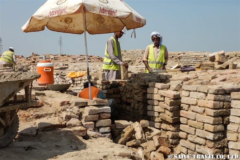
Photography by Yuka Fujimot, Oct 2022Restoration work was underway in the areas damaged by the flood.

A donkey cart carrying bricks for repair. By 2000 BC, cities in the Indus civilization had already started using standardized baked bricks. Baked bricks were introduced earlier in the cities of the Indus civilization, compared to the Mesopotamian and Yellow River civilizations. Even today, you can see the work of making baked bricks in the farming villages around Mohenjodaro. They still use the same brick construction as used in the Indus Civilization era, to this day.

Thick brick walls that form the streets between houses (DK Area).

In the DK area, which is said to have been an urban area, there is a building that is thought to have been an “aristocrats’ house.” It is thought that this chimney-like “well” was able to draw water from the second floor of the house.

This is the sewage system of the SD area, also called the Citadel District.

It seems they even had stones to cover the sewage system.

This is a scene of the SD area that represents Mohenjodaro. What is thought to have been a “bathing pool” and the drainage system from it. It is a very gorgeous site that inspires the imagination with a Gandharan Pagoda at the peak of this city.

It is said that Bitumen (asphalt) was used to help waterproof the walls of pools in this bathing area. It is on display at the Mohenjodaro Museum.

By the way, my recent passion is seeing the sunset at Mohenjodaro.

The city ruins in the light of the setting sun. Due to the flood damage this year, the waterlogged fields could be seen shining beyond the grounds.


Photos & text: Mariko Sawada

Visit: Nov 2022, Mohenjodaro, Sindh

*For inquiries and consultation, please go to Indus Caravan

*Please follow us on YoutubeInstagram & Facebook

Category : - Mohenjodaro > - Monument / Heritage of Sindh > ◆ Sindh
Tag : , , , , , , , , , , , , , ,

Indus Highway, trip to Interior Sindh

First of all, I would like to express my heartfelt sympathy to those who have been affected by the flood disaster caused by the torrential rain from June to August 2022. Restoration work is progressing in some areas, and travel arrangements to Sindh and Balochistan regions were made, though we could see different sights than before, such as flooded fields.

The National Highway 55 (N-55), commonly known as Indus Highway, which goes north from Hyderabad, is a lifeline of West Sindh running through the west bank of the Indus River. During the fall harvest season, many trucks travel the road loaded with grain and chaff.

This year, due to the summer disaster, both sides of the road were still flooded, and there were many places waiting for the water to recede, unable to harvest the fields.

In some places, the fields were so water-logged they looked like lakes. I was sad to see so many people who had lost their homes and living in camps.

While some fields were water-logged, there were others that were being harvested. November is the season for harvesting rice.

I was really grateful to see this beautiful sight, which in any other time, would have been totally normal.

They were working on transferring the roadside piled up rice husks onto the trucks. Using wooden sticks to support it, they used sticks to create giant balloon-like cargo structures on the tops of the trucks.

A camel carrying firewood came our way. It is brought from the villages to the collection areas along the Indus Highway.

This firewood is an important fuel in the villages.

A handmade bell was decorated with cowry shells. A very traditional decoration, this is a camel very cherished by the owner. 

I was having lunch at a restaurant along the Indus Highway when I was invited to a wedding in the hall next door. “Wedding Gifts” decorated with bank notes were hung around the groom’s neck one after another.

Travelling on the Indus Highway with a different scenery than usual, we will soon enter the east road and reach Mohenjodaro. There were many submerged fields on the way to Mohenjodaro. I pray that the water will recede soon.

Photo & text: Mariko SAWADA
Visit: Nov 2022, Indus Highway, Sindh
*Please contact us for your own personalized itinerary.

*Please follow us on Youtube, Instagram & Facebook !

Category : - National & Indus Highway > ◆ Sindh
Tag : , , , , , , , , , , , , , , , , , ,

Lammergeier, Bearded Vulture of Khunjerab National Park

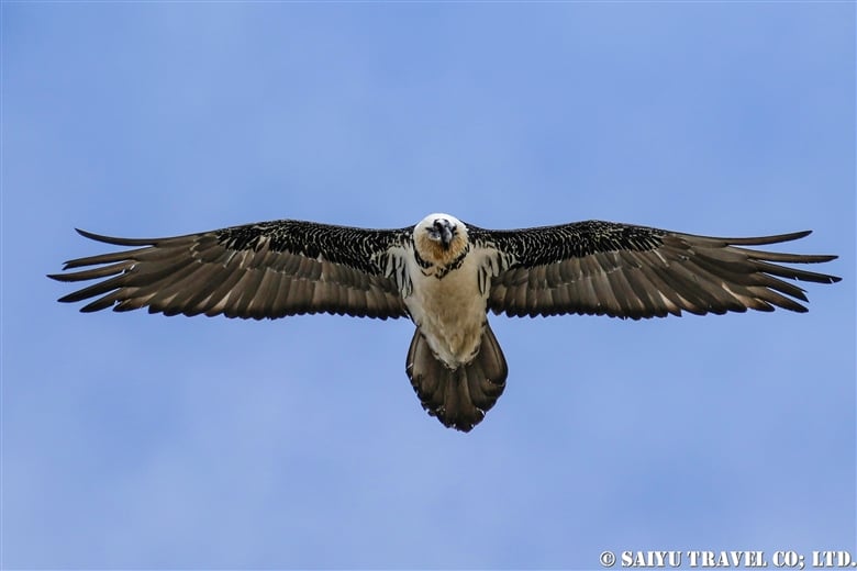
This is the Bearded Vulture in Khunjerab National Park. Just as its name suggests, it looks like a vulture with a beard.

The Gypaetus barbatus is also known as the lammergeier, which are a large bird of prey that makes up the only one in its’ genus Gypaetus and is most closely related to the Egyptian vulture(Neophron percnopterus), and with the Palm-nut vulture(Gypohierax angolensis) they form a subphyla of the vulture subfamily. The tail is a rare diamond-shaped one, uncommon among raptors.

These bearded vultures feed on carrion, mainly bone and marrow. Small bones are swallowed whole, and digested by strong gastric juices. Larger bones that have lots of marrow are dropped from the sky, to break them apart and make them easier to consume.

This time, I saw a bearded vulture dropping a bone at Khunjerab Pass (around 4,600m). It may be hard to see because it’s quite far away, but I got a video of its behavior.

The Lammergeier dropping a bone from high above: Bone crasher!

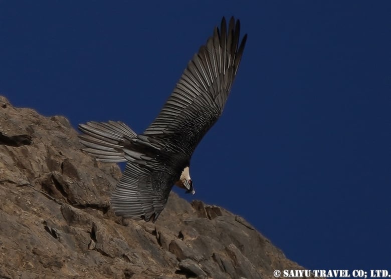
The bearded vulture is a large bird with a total length of 115 cm and a wingspan of nearly 3 meters. Sometimes I am so overwhelmed by its size when it flies right overhead.

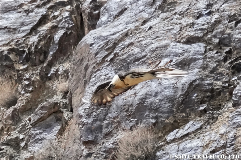
The bearded vulture as it descends along the cliffs of the Khunjerab River.

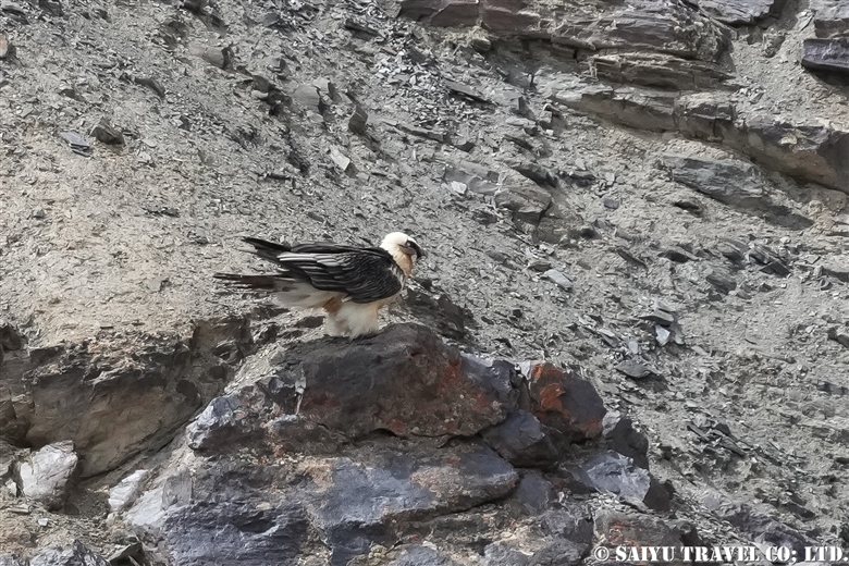
The Lammergeier found a carcass of an ibex on the banks of the river and perched on a rock nearby. It must have been frustrated that it couldn’t get into the narrow riverbed, since its wings might not fit into the space.


Photo & text : Mariko SAWADA

Observation :Spring 2022, Khunjerab National Park

For observation, photography of wildlife, birds of Pakistan, please contact us, Indus Caravan.

Youtube Channel – Indus Caravan  

Category : = Video Clip Gilgit-Baltistan > - the Karakoram Highway > ◆ Gilgit-Baltistan > ◇ Birds of Pakistan > - Khunjerab National Park
Tag : , , , , , , , , , , , ,

CONCORDIA 360 DEGREE

We stayed at Concordia on a truly cloudless, crystal clear morning in mid-June. The video was rattled by manual paaning, but I made a 360-degree mountain view video from Concordia.

CONCORDIA 360 DEGREE


Image by Mariko SAWADA

A big thank you to the the whole Baltoro Glacier trekking team for working with us!


Related article

Youtube : Our baltoro Trek in 1 Min !

K2 & Baltoro Glacier Trekking 2022 (Part 1) Skardu to Paiju

K2 & Baltoro Glacier Trekking 2022 (Part 2) Paiju to Khoburtse

K2 & Baltoro Glacier Trekking 2022 (Part 3) Khoburtse to Urdukas

K2 & Baltoro Trekking 2022 (Part 4) Urdukas to GoreⅡ

K2 & Baltoro Trekking 2022 (Part 5) GoreⅡ to Concordia

Staying in Concordia, surrounded by the high Peaks of the Karakorum: K2, Broad Peak, Gasherbrum Mountain Range

★★★★★

*Contact us, Indus Caravan for more information or to make arrangements for your Baltoro Glacier trek.

Category : - Baltoro Glacier & Concordia > = Video Clip Gilgit-Baltistan > - Baltoro Glacier & Concordia > ◆ Video Breathtaking Views of Pakistan > ◆ Gilgit-Baltistan > ◇ Mountain of Pakistan > - Karakorum Range
Tag : , , , , , , , , , , , , , , , , ,

Our Baltoro Trek in 1 min

Here’s a staff-centric video clip of our first post-pandemic Bartolo Glacier trek in June 2022! Well done to all the guides, kitchen staff, sardars, and porters who made the round trip to Concordia multiple times this season!

Our Baltoro Trek in 1 min

Image by  Mariko SAWADA

A big thank you to the the whole Baltoro Glacier trekking team for working with us!


Related article

Youtube : CONCORDIA 360 DEGREE

K2 & Baltoro Glacier Trekking 2022 (Part 1) Skardu to Paiju

K2 & Baltoro Glacier Trekking 2022 (Part 2) Paiju to Khoburtse

K2 & Baltoro Glacier Trekking 2022 (Part 3) Khoburtse to Urdukas

K2 & Baltoro Trekking 2022 (Part 4) Urdukas to GoreⅡ

K2 & Baltoro Trekking 2022 (Part 5) GoreⅡ to Concordia

Staying in Concordia, surrounded by the high Peaks of the Karakorum: K2, Broad Peak, Gasherbrum Mountain Range

★★★★★

*Contact us, Indus Caravan for more information or to make arrangements for your Baltoro Glacier trek.

Category : - Baltoro Glacier & Concordia > = Video Clip Gilgit-Baltistan > - Baltoro Glacier & Concordia > ◆ Video Breathtaking Views of Pakistan > ◆ Gilgit-Baltistan > ◇ Mountain of Pakistan
Tag : , , , , , , , , , , , , , , , , , ,

Summer on the Deosai Plateau and Wildlife We Encountered While Camping

This is a summary of our visit of the Deosai Plateau during the summer; the wildlife and scenery we experienced while camping and exploring the area.

The summer of 2022 was unusually dry on the Plateau. The Deosai summer, which is normally full of water with the carpet of alpine flowers in full bloom, this time was super dry and the plants were all the like their autumn colors. There was a lack of snowfall in the winter, earlier in the year, so it caused the high plains to be dry early on. In another blog, I will write about the impact of this big change on the Himalayan Brown Bears.

Past articles about the Deosai

The Deosai Plateau on a sunny day is remarkable, with crystal clear rivers, wetlands and mountains inviting you to stay.

The Long-tailed Marmot(or Golden Marmot). These are the same species as the marmots we see near the Khunjerab Pass, but will have a more muted coloration. (The Khunjerab Pass marmots really live up to their names as the “Golden” marmot!)

A male Citrine Wagtail. So striking in the breeding season! Breeding in the thickets along the river, we saw them carrying beaks full of insects to their chicks in the mornings and evenings.

The male Horned Lark who was busy feeding their chicks as well. I was there in mid-July, which seemed to be the season for fledging. It was nerve-wracking to see the baby birds that could not fly so well, as they were so close to the roadway.

Robin Accentor

The Robin Accentor. I didn’t really see it near the campsite, but we saw it while observing the livestock grazing in the Shatung area. In Pakistan, this bird can only usually be seen in a limited area from the Deosai Plateau to the northern area.

We walked every day in search of the Himalayan Brown Bear. Due to the exceptionally dry weather this summer, the brown bears were not in the areas where they are usually seen. There were days when we couldn’t find them, even though we looked all day, into the evening.

After days of walking, there was a big bear cub. It may have had a mother bear nearby, or maybe it was recently independent.

There was another huge Himalayan Brown Bear engrossed in eating grass. Thanks to the wind direction, I was able to get even closer to observe it.

When I returned to the campsite, we had large trout waiting for us (note: it was caught by the staff with a proper permit from the national park). The Deosai Plateau contains both native and exotic trout released for fishing by the British during the colonial period. I don’t know which one this is, but it seems the native trout is a very rare species called an “Indus Snow Trout.”

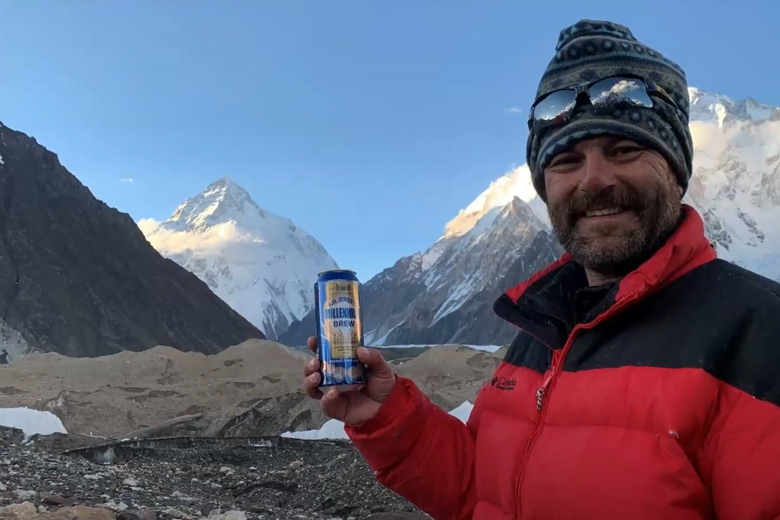
Seeing trout makes me a little thirsty for Beer. We had a toast with Pakistani beer, Murree Beer (Caution: the altitude is 4,000m, so don’t try it). This can is the Murree Brewery’s Millennium Beer, which I personally think is the most delicious beer. It is the British Colonial legacy that I appreciate the most.

The starry sky of the Deosai Plateau. I really recommend taking photos of the dark skies of the Deosai Plateau.

Himalayan Brown Bear

A brown bear came to our campsite…it was attracted to the garbage, looking for food and is seems it comes often. It was clearly visible in the camera traps.Due to the abnormally dry weather this year, it was difficult to see the brown bears and so few flowers were blooming on the plateau. I just pray that the abnormal weather will not upset the ecology of this special place.


Images & text: Mariko SAWADA

Observation: JUL 2022, Deosai National Park, Gilgit-Baltistan

Visit our web site “Wildlife of Pakistan

YouTube : Himalayan Brown Bear in Autumn

Category : - Himalayan Brown Bear > ◆ Gilgit-Baltistan > - Deosai National Park > ◇ Birds of Pakistan
Tag : , , , , , , , , , , , , , , , , ,

Searching for Himalayan Brown Bears in the Deosai Plateau in the Summertime

In the summer of 2022, finding Himalayan brown bears to observe was quite a struggle. The National Park Staff and I, searched, and wondered why they weren’t in the places we usually see them.

The first reason that came to my mind was the “increasing number of tourists.” but it’s not something that has happened just in this one year. Second, the nomadic people came to the Deosai Plateau brought their livestock into the brown bear area. Definitely, their presence has a certain impact. However, we could not even find the bears in the core zones…so I suppose the main reason for the lack of bears might be the ‘dryness’ due to the exceptionally low amount of snowfall this winter. The grasses, which are the favorite food of the bears, has not grown in the usual areas, so the National Park staff are guessing that the bears have moved to different areas in search of better food sources.

Unfortunately, there is very little research that has been done on the Himalayan brown bears. To be honest, even the published population estimates are not very accurate.

The easiest place to see bears is the “Watching Point” which is just behind the Barapani National Park Station. If you have any luck, you will get to see a mother and cubs feeding on the hill nearby. However due to the distance, make sure to bring good binoculars or have a scope with you.

This time, during our visit, we could walk to 4 different areas in search of the bears. While walking, we could see Nanga Parbat (8,126m), the 9th tallest peak in the world, from various places around the Deosai Plateau.


This is a temporary hollow used by the brown bears to sleep. There are two indentions, one big one and one small one. Looks like it was used by a mother and her cub.

We also found lots of feces, large piles (mother bear) and smaller ones (cub). However, according to the national park staff, the newest one was already 3-4 days old and we didn’t find any fresh droppings. So most likely, the mother and cub has moved on to a new place already.

We scanned the core zone. Finally, we happened upon a Himalayan brown bear.

It was a very young bear!

It must have smelled us, so it stood up and started looking around for us.

It has become aware of our presence. As soon as it confirmed our presence, it put as much distance as it could from us.

It ran across the meadow until it disappeared. It is quite a young bear, so perhaps the mother was still nearby, or maybe it had just become newly independent. I pray that this little one can grow up safely.

A different, bear, this one a large one and totally engaged in eating the grass.

It was so absorbed in eating, that it hardly looked up at all. While eating, we moved closer and we gradually closed the distance. The wind direction was right, taking our smell away from the bear, and it was our chance.

We got lots of photographs.

The bear never realized we were there, and just kept eating. Surrounded by the alpine plants, I was able to enjoy the sights of a bear preying on insects in the grass, observing the natural behavior.

I have tried observing the brown bears several times before, but this time compared to in the past, we had a hard time finding them and had to walk long distances. The impact of the extreme weather on the Deosai Plateau and the effect it has on the brown bear was quite terrifying.

The Deosai Plateau, which is usually covered in lush greenery and alpine flowers, but this summer was so dry. The scene of so many tourist cars driving through the Plateau and the clouds of dust behind the vehicles made me fearful that one day, Deosai could turn into a desert.


Image & Text : Mariko SAWADA

Observation : JUL 2022, Deosai National park, Gilgit-Baltistan

Visit our web site “Wildlife of Pakistan

YouTube : Himalayan Brown Bear in Autumn

Category : ◆ Gilgit-Baltistan > - Himalayan Brown Bear > - Deosai National Park
Tag : , , , , , , , , , , , , , ,

Staying in Concordia, surrounded by the high Peaks of the Karakorum: K2, Broad Peak, Gasherbrum Mountain Range

This is Concordia, The end of the Baltoro Glacier trek. It is a sought-after destination surrounded by 360 degrees of high peaks like K2.

In Latin, the word “Concordia” means “confluence and harmony,” and was given this name due to it being a confluence point between the Baltoro and Godwin-Austen Glacier. From here, climbers will set out for peaks like K2, Broad Peak, Gasherbrum Mountains Basecamp, and the Gondogoro La (Pass).

The first morning after our arrival in Concordia, the camp was covered with fresh snow. With patches of blue sky coming through and since the forecasted weather was clear, I took the opportunity for a photo op, since we made it all the way here.

K2 & Baltoro Glacier Trekking 2022 (Part 1) Skardu to Paiju

K2 & Baltoro Glacier Trekking 2022 (Part 2) Paiju to Khoburtse

K2 & Baltoro Glacier Trekking 2022 (Part 3) Khoburtse to Urdukas

K2 & Baltoro Trekking 2022 (Part 4) Urdukas to GoreⅡ

K2 & Baltoro Trekking 2022 (Part 5) GoreⅡ to Concordia

K2 emerges from the clouds, just beyond the campground. It was a moment I had eagerly anticipated, finally seeing the mountain break through the clouds.

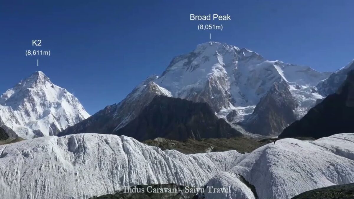
The view of K2 got even better. At 8,611m it is the second highest mountain in the world, just after Everest. It is a majestic mountain.

This is Broad Peak (8,051m) which came into full view before K2. Broad Peak, as it is aptly named, has a wide peak. It is the 12th highest mountain in the world and is also the first mountain to be scaled for the 8,000m Summit Challenge.

Not a cloud in the sky. A short walk from the campsite, this was taken from a place where we could see Angel Sar (6,858m). Just east of here, we can see the Gasherbrum Group, and to the south, was Baltoro Kangri and Chogolisa.

Angel Sar (6,858m) is a beauty, just Northwest of K2.

Baltoro Kangri, as seen from Concordia. There are several peaks from west to east, and the highest is said to be 7,312m high.

Vigne Peak(6,195m)at left, Khumal Gri(6,851m) at right. Chogolisa (7,668m) is a flat peaked mountain, peeking from behind a wall of ice. Heading west through this valley is the famous Gondogoro-la (Pass), which leads to the Hushe Valley.

During the day, the porters relax at the campsite. They sing, dance and are just having fun. They spend the entire summer going from Askole to Concordia and Base Camp and back, never returning to their village until the end of the season. We have worked with this same crew for years, and I am so grateful to them.

The Balti people make a fried bread called ‘Prantha.’ Do they mean “pratha?” perhaps but, anyway it is a fried bread. When it’s freshly made, it is the best.

The commemorative photo spot is a must. On June 13, 2022, we arrived in Concordia, the first Baltoro Glacier trek made by Saiyu Travel since the Covid-19 Pandemic.

We are filled with appreciation to the guides, porters and for being able to get back to work. We were the second squad to reach the Concordia this season.

Since we are here, made time for Gamow Bag practice.

This year’s Concordia has a 4G network!  The 4G is provided by the SCO (a mobile company in the mountainous regions of Pakistan) you can pick it up from around Gore II and is being sent out from Concordia. Of course, the best part of this is that you can see the weather forecast!

The evening sunlight setting on Gasherbrum Ⅳ(7,925m). These peaks of the Gasherbrum mountain range rise over Concordia.

I grabbed a shot of K2 and Broad Peak, just before the moonrise.

On the third night, we could finally get a scene of the moon and starry sky over K2. The moonlight illuminates K2 just as it gets dark.

Mitre peak (6,010m) is to the south of the campsite. This is the moon rising, not the sunrise.

This is daybreak hitting the Gasherbrum Mountains.

Gasherbrum IV peak shoulders the dramatic sunrise.

Welcoming the sunrise at Concordia.

Today’s weather – Clear.

The fine weather continues, and there was plenty of time for the staff to get commemorative photos. Then it was time to say bye to K2 and leave.
It was like a dream, and we left Concordia the next day.

Image & Text: Mariko SAWADA
Trek Date: Mid-JUN 2022

*The altitudes and distances traveled from site to site that are listed, are based on our own measurements and GPS equipment. Please note that these may differ from other official books or reference materials.

*Contact us, Indus Caravan for more information or to make arrangements for your Baltoro Glacier trek.

Category : - Baltoro Glacier & Concordia > - Baltoro Glacier & Concordia > ◆ Gilgit-Baltistan > ◇ Mountain of Pakistan
Tag : , , , , , , , , , , , , , , , , , ,

Snow Leopard After The Hunt

Abul was scanning the mountains for the snow leopard that he had just heard. He quickly came back and told us “Congratulations!” Through his binoculars, he could find the snow leopard, sitting with a freshly caught ibex (with its head cracked, at that!) and the snow leopard had a hurt eye. It was such an exciting moment!

Youtube “Snow Leopard after the hunt”

Article related “Snow Leopard”      Feature “Widlife of Pakistan”

The two were just under a steep cliff dropoff, suggesting that they had both had a fall from a considerable height, which had been enough force to crack the head of the ibex open. There were signs of the ibex then being dragged to the hollow of this rock, were the snow leopard was now sitting.

Sadly, one of the eyes of the snow leopard was quite swollen and seemed to be impaired now, showing that the ibex was not the only one who suffered terribly from this incident. Abul began to voice his concerns that perhaps it was a serious injury that might prevent the leopard from being able to hunt in the future, spelling out its death. Not only thinking about the pain it must be in, but also it was quite heartbreaking to think that it might not survive for very long after this…

This is the moment I realized we were witnessing just how harsh the reality is for a wild carnivore.

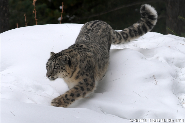
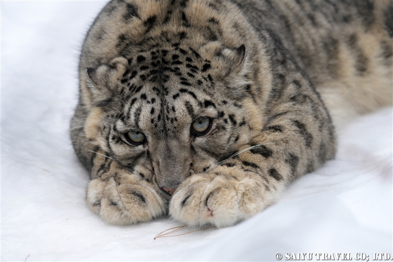
Having said that, the sleeping snow leopard, then just showed off their cat-like expressions.

Tired from hunting + having a full tummy = a great sleep!

It seemed to have zero concerns that we were there watching it.

We were watching it through the spotting scope and getting photos/videos. I attached my iPhone to the Kowa scope (TSN-663) that I recently purchased this spring.

Those toe beans…

It was quite a large cat.

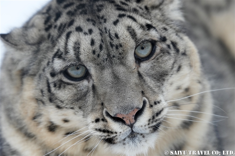
The snow leopard’s grey eyes that opened with a start.

After this, the snow leopard got up and went towards the back of the rock hollow. It really broke my heart to see its appearance, apparently quite injured, as it could hardly walk.


Photo & text : Mariko SAWADA

Observation :Apr 2022, KVO conservation area, Gilgit-Baltistan, Pakistan

*Contact us, Indus Caravan for more information or to make arrangements for observing wildlife of Pakistan.

*Youtube    Facebook   Instagram  << Please check our update activity !

Category : - Snow Leopard > ◆ Gilgit-Baltistan > - the Karakoram Highway > - Gojar
Tag : , , , , , , , , , , , , , , ,

K2 & Baltoro Trekking 2022 (Part 5) GoreⅡ to Concordia

Finally, we made it the leg of the hike to Concordia. The camp on the glacier of Gore II is cold (in June), so we made early preparations and left quickly.

K2 & Baltoro Glacier Trekking 2022 (Part 1) Skardu to Paiju

K2 & Baltoro Glacier Trekking 2022 (Part 2) Paiju to Khoburtse

K2 & Baltoro Glacier Trekking 2022 (Part 3) Khoburtse to Urdukas

K2 & Baltoro Trekking 2022 (Part 4) Urdukas to GoreⅡ

K2 & Baltoro Trekking 2022 (Part 5) GoreⅡ to Concordia

Staying in Concordia, surrounded by the high Peaks of the Karakorum: K2, Broad Peak, Gasherbrum Mountain Range

We walked about 6 km from Gore Ⅱ (altitude 4,271m) to the 4,400m point stopping for a light meal, and then walked an additional 7.5 km to the campsite of Concordia (4,596m). It is an exciting hike, as the mountains of Concordia get closer and closer with each turn.

Morning at the Gore II camp. It’s going to be a cloudy day today, but the weather forecast says it’s going to be sunny for the entire two days of our stay in Concordia, so I’d like to expect it to be pleasant. Even so, the Masherbrum (7,821m) that emerged between the clouds in the morning sun, was really exceptional.

The porters are in a hurry. The porters and mules who we have contracted to accompany us only upto Concordia, quickly take our luggage back down. The glacier is a very harsh environment for the animals, and it is not a place to stay any longer than necessary.

The exhaled white breath of the hard-working porters.

Leaving Masherbrum behind, we head out from Camp.

A horse with our luggage (not a mule, but a horse). This year, we just redesigned the Saiyu Travel and Indus Caravan logos on the khaki green duffle bag.

Our light meal while on the glacier.

From here, you can see the Muztagh Tower (7,273m), a mountain on the border with China to the north. The name “Muztagh” is often heard in this area, but it means “mountain of ice and snow” in the Turkic language.

The Gasherbrum Mountains get closer as we approach them.

The view of the peaks of the Gasherbrum Group just before reaching Concordia.

We have to go through the campground of the Pakistani Army which is totally littered with trash and the CNKP (Central Karakoram National Park).  Then we finally reached our destination for this leg of the trip, where we can relax a bit for the next 3 nights.

We set up the Kitchen Tent and Dining Tents with Miter Peak (6,010 m) as the backdrop. It started to snow on this first night.

At nightfall, I got one shot as the snowfall subsided. Broad Peak (8,051 m) and K2 (8,611 m) are covered with clouds and the snow covering the ground. I am so looking forward to tomorrow morning!


Photo & text : Mariko SAWADA

Trek date : Mid -JUN 2022

*The altitudes and distances traveled from site to site that are listed, are based on our own measurements and GPS equipment. Please note that these may differ from other official books or reference materials.

*Contact us, Indus Caravan for more information or to make arrangements for your Baltoro Glacier trek.

Category : - Baltoro Glacier & Concordia > - Baltoro Glacier & Concordia > ◆ Gilgit-Baltistan > ◇ Mountain of Pakistan
Tag : , , , , , , , , , , , , , , , , , ,

TOP